Public footpaths are the responsibility of the County Council not the Parish Council although parish councils do have some rights to keep footpaths open. The information below is provided as a guide to walkers.
Partly prompted by Covid lockdown constraints, walkers have been using the footpaths in Sunningwell to an increasing extent. Although this is doubtless beneficial to the general public well-being, there is a downside to the health of the countryside, particularly during spells of winter wet weather. Footpaths, especially those across fields with crops planted, become churned up with mud and walkers sometimes tend to deviate from the path so as to avoid the “mud bath” along the original path alignment. This results in the crop at the sides of the path being trampled and destroyed, and represents a loss to the farmer when the crop is harvested. Often, walkers deviate from the path because they do not have suitable footwear to cope with mud underfoot. As many of the footpaths are in low lying areas, or in areas with a clay underlay, which tend to accumulate water and are poorly drained, SPC urges all walkers on footpaths in Sunningwell Parish to wear waterproof boots or wellies and stay on the path alignment as much as possible. If there is a blockage or obstruction it is permissible to make a short detour around taking care not to cause damage to any surrounding crops etc.
Increased footpath usage has also sometimes resulted in walkers using footpaths that are neither Public Rights of Way nor a Permissive Footpath which can be walked only with the permission of the landowner.
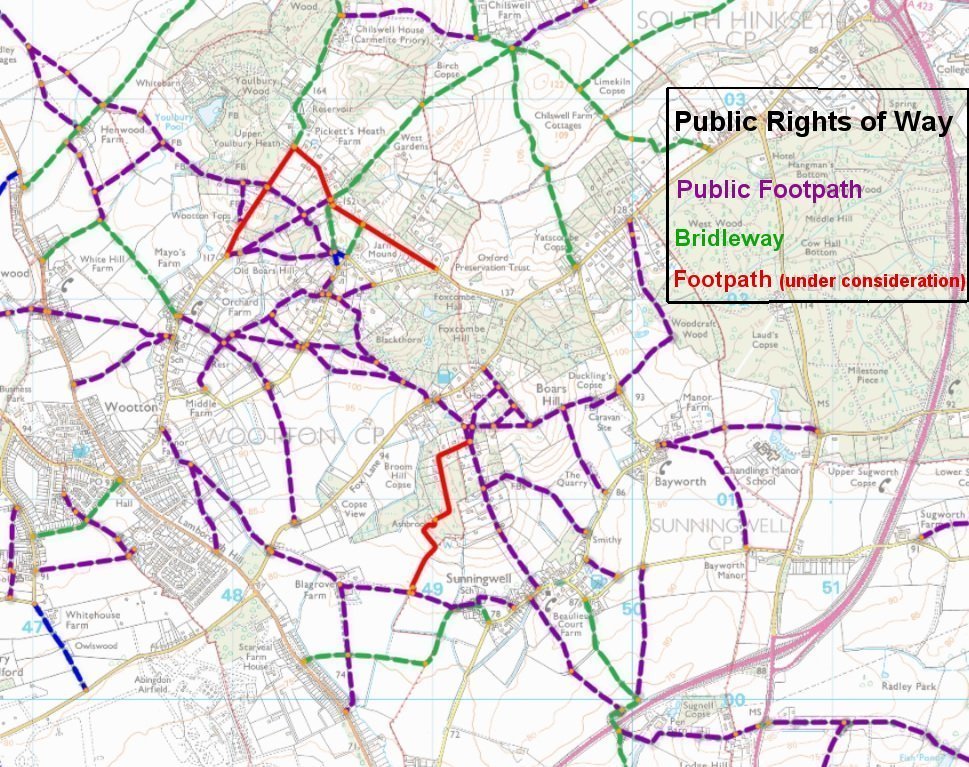
The map above is taken from the Oxford County Council site where further viewing options are available.
Public Rights of Way in Sunningwell Parish may also be seen marked in red or purple on this map.
There is currently a nationwide campaign by The Ramblers organisation (the so-called Lost Paths campaign) to get paths that were demonstrably used in the past reclassified as Public Rights of Way, through what is called a Definitive Map Modification Order; (DMMO). This process is administered by Oxfordshire County Council, which considers the evidence (both documentary evidence from old maps and user evidence from walkers who have used such paths within their lifetimes). Paths currently under consideration for “modification”, ie possible reclassification as Public Rights of Way, are marked in red on the OCC map above. OCC is the adjudicator in this process, which may be initiated by any citizen, for any claimed path, under the Countryside and Rights of Way Act 2000. It should be noted that footpaths which are the subject of a DMMO claim do not become public rights of way until so determined by Oxfordshire County Council and shown on the Definitive Footpath Map issued and maintained by OCC.